
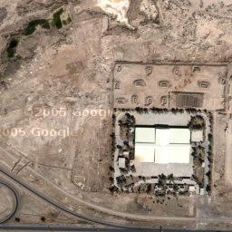
Not sure how new this is, but I recently discovered that you can see satellite imagery of a lot more places than the US. For example, Iraq. This is the sweet-ass palace I had the misfortune of staying in for about a month. If yo
u pan north you can see the parade field and Iraqi tomb of the u

nknown soldier. They even have imagery of Fallujah farther west. This is the MEK compound we stayed in while I was there, formerly occupied by a group of Iranian Islamic women terrorists fighting the Iraqi regime (hotties every last one).
 Not sure how new this is, but I recently discovered that you can see satellite imagery of a lot more places than the US. For example, Iraq. This is the sweet-ass palace I had the misfortune of staying in for about a month. If you pan north you can see the parade field and Iraqi tomb of the u
 nknown soldier. They even have imagery of Fallujah farther west. This is the MEK compound we stayed in while I was there, formerly occupied by a group of Iranian Islamic women terrorists fighting the Iraqi regime (hotties every last one).
I had heard google added "the rest of the world" but I haven't really played around with it. These are insane. There are also a number of "google hack pages" which people have used to display data on-top of a google map, here's one that got attention from the national media chicagocrime.org. A guy downloaded chicago crime stats and used the google map api to map stuff. The CPD evidently is working with him and may provide more recent data.
ReplyDelete